The State of California has released its final report on how it will work to achieve the “international movement to conserve natural areas across our planet,” entitled “Pathways to 30 x 30 California.” In October of 2020, Governor Newsom signed the “Nature-Based Solutions” Executive Order which triggered the development of the plan.
Unlike the Biden Administration’s two 30 x 30 national reports, California’s plan defines “conservation.” Their definition is “land and coastal water areas that are durably protected and managed to support functional ecosystems, both intact and restored, and the species that rely on them.”
They have determined that 24 percent of the land in California already meets this definition, and that the “GAP status codes 1 and 2 are consistent with our definition of conservation.” These GAP codes are the same codes the Department of Interior has used to determine 12 percent of the lands in the United States are permanently protected. They come from the U.S. Geological Survey GAP Analysis, which catalogs the level of protection of lands across America.
Although over 50 percent of the land in California is already owned by local, state and federal governments, only those lands that are “durably protected,” meaning that permanent protections for conservation purposes are in place, qualify as “conserved.”
The plan identifies nine strategic actions to acquire the additional acreage, of which the first two listed are “Land Acquisitions” and “Conservation Easements.” It identifies some of the additional areas to be targeted as those which are adjacent to already protected areas, necessary to connect large ecosystems and create wildlife corridors. It discusses the need for partnership, cooperation and coordination between state, federal and tribal governments to acquire the remaining 6 percent, but fails to include local governments, such as counties, in this process.
With just over 100 million acres of land in the State, the goal by 2030 is to add 6 million more “durably protected” acres. Coincidently, the last two fire seasons in California destroyed 6,826,000 acres of primarily state and federal land, according to Cal Fire. Very few of the acres impacted were private lands.
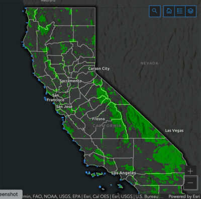
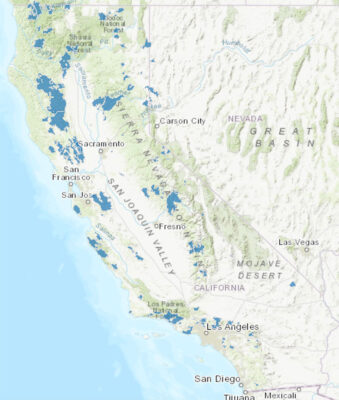
To better illustrate this point, compare the California State Geoportal map of the largest wildfires in the state over the past five years with the 30 x 30 Conserved Areas map. Notice, the lands on fire are largely the same lands “protected” under the environmental agenda.
Environmentalists blame the fires on climate change, however, the map presents a more tangible explanation; the longer the lands are in a protected state, the more susceptible they are to destruction by wildfire. This is the course environmentalists have set for at least 30 percent of America’s lands and oceans.
Source: 30 x 30 Conserved Areas Explorer
Source: California State Geoportal. Map of largest wildfires in California between 2016 and 2021.