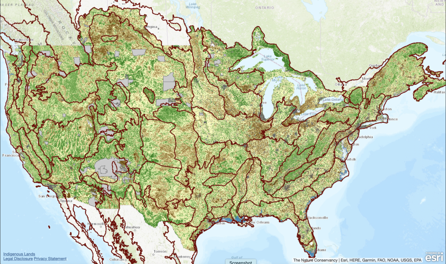
Two online mapping tools have been created to help the public identify lands in America that should be protected under the “climate crisis” agenda. The Nature Conservancy (TNC) released their mapping tool last year, the “Resilient Connected Network,” focusing on achieving ecosystem connectivity across state and regional boundaries. The second mapping tool, “The Climate Atlas,” was created by four environmental groups and focuses on State and Federal lands they are targeting for increased protections.
TNC describes the purpose for its mapping tool as follows:
“Through protecting habitat, we can help the world’s species be more resilient to climate change and other human disturbances, such as pollution or agriculture. To have the greatest impact on biodiversity, we need to protect lands with a variety of habitat that support wildlife now and into the future. TNC has developed a mapping tool to identify exactly those places in the U.S., called the Resilient Connected Network.”
For instance, they have identified the “Southern High Plains,” an area including lands in Colorado, Kansas, Oklahoma, Texas, and New Mexico, as one of these critical areas in need of protection. According to their analysis, only 11 percent of the lands in this region are preserved. The U.S. Fish and Wildlife Service based its proposed decision to federally protect the Lessor prairie chicken, whose habitat is defined along the same boundaries, for the same reason — not enough of the bird’s habitat is “protected.”
While the TNC map does not identify how much of the land in this region is privately owned, the USFWS does. Approximately 97 percent of the LPC habitat is private. Making the claim, as TNC does, that only 11 percent of these lands are protected, is really an issue of control and not conservation. The best managed lands are those with a landowner who manages it daily, makes a living from that land, and passes it down to the next generation in better condition. As a result, these are the places where species and wildlife are abundant.
Deceptively, TNC leads the public to believe that 89 percent of the lands in this specific area are unprotected, that species are in peril, and that agriculture is to blame. As they manipulate the public sentiment, they carry out their campaign to be the private landowners greatest advocate helping them conserve their lands by offering conservation easements, through which the land trust, or the federal government, gains primary control of the property.
TNC’s map identifies “natural highways and neighborhoods” for species that cover “33 percent of the continental U.S.” They expect this project will “bring together government agencies, land trusts, private landowners, Indigenous communities, and other stakeholders to develop conservation plans that will help nature thrive on a national scale while meeting local needs.”
Additional key target areas they identify are: (1) The Monsoon Passage – Nevada to Idaho; (2) Cumberland Forest Project – Virginia, Kentucky and Tennessee; (3) Washington’s Hoh River – Washington; and (4) Iowa’s Loess Hills – Iowa.
The second mapping tool, “The Climate Atlas,” focuses its marketing campaign on increasing protections for lands already owned by State and Federal governments. It helps users to identify the lands that should be further restricted by viewing the data in the following ways: (1) “View baseline data on the health and status of a landscape, and what the government is currently doing (or not doing) to protect it;” (2) “Identify which public lands offer the best opportunities for storing carbon, supporting wildlife and species richness, and protecting biodiversity;” and (3) “Help inform and prioritize which public lands to protect based on the values you select.”
Landowners can take a deep dive into these public maps to see what lands environmentalists have targeted to be protected under the Biden Administration’s 30 x 30 plan. Keep an eye out for land trusts and federal agencies to be active in these areas, promoting conservation easements, conservation programs, wildlife corridors, grassland protections and all the other tools in the toolbox they can wield to increase land use restrictions.


