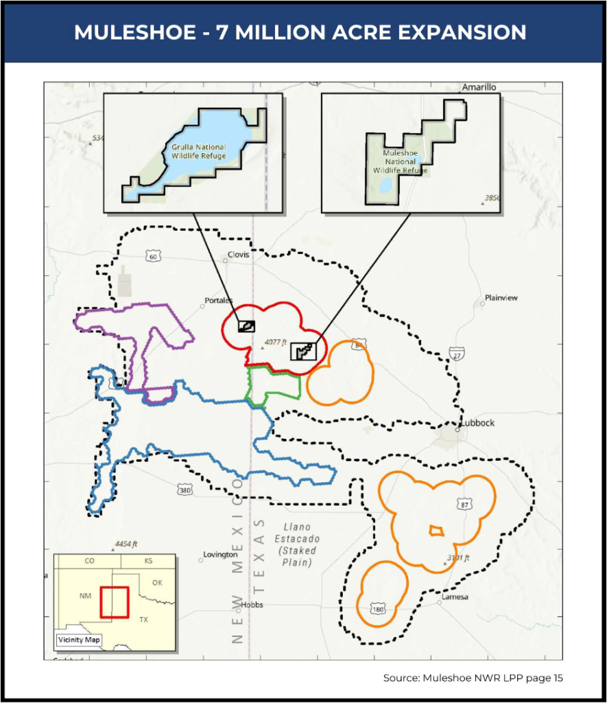
Muleshoe National Wildlife Refuge is Attempting to Expand Acquisition Boundary from 6,440 acres to 7,000,000 in TX and NM.
What is the plan? On April 16, 2024, the Muleshoe National Wildlife Refuge, located outside Muleshoe, Texas, released a final Land Protection Plan (LLP). The federal government seeks to expand the “authorized acquisition area” from 6,440 acres to 7 million acres – without Congressional authorization.
Who will be impacted? The plan area is located in Lamb, Bailey, Palmer, Castro, Yoakum, Lubbock, Hockley, Cochran, Hale, Gaines, Dawson, Garza, Lynn, and Terry Counties in Texas; and Lea, Chaves, Roosevelt, De Baca, and Curry Counties in New Mexico.
Removing nearly three-quarter million acres is a direct attack on the oil, gas, and mineral industries, agriculture production, and local economies.
WHAT ARE THE NEXT STEPS?
The Muleshoe project is in the final phases. The last step is for the U.S. Fish and Wildlife Service Director Martha Williams to authorize the plan. Even though the National Wildlife Refuge System has been actively working on this since March of 2022, they have never directly noticed the counties, other local governments, or landowners impacted.
There will be no Congressional oversight. There will be no public vote.The federal government will do this by administrative fiat.
The Biden Administration has targeted this region for permanent protection as a part of their unauthorized 30×30 land grab (a.k.a “America the Beautiful”). They listed the Lessor prairie chicken and Dune sagebrush lizard as endangered to restrict land uses, and now are attempting to physically acquire this resource-rich land.
HOW YOU CAN FIGHT BACK!
Get Educated
American Stewards of Liberty is actively organizing the counties, local governments, landowners and elected leaders to stop the Muleshoe NWR land grab.
Download these free resources and make sure your neighbors and local officials know about the land grab.
Muleshoe National Wildlife Refuge is attempting to expand the acquisition boundary from 6,440 acres to 7,000,000 in TX and NM without Congressional authorization.
2.
From within this area, they are planning to add 700,000 acres to the Refuge by directly buying private property or acquiring permanent conservation easements.
3.
Federally acquiring nearly three-quarter million acres from this region is a direct attack on the oil, gas and mineral industries, agriculture production, and local economies.
4.
The Biden Administration has targeted this region for permanent protection as a part of their unauthorized 30×30 land grab (a.k.a “America the Beautiful”). They listed the Lessor prairie chicken and Dune sagebrush lizard as endangered to restrict land uses, and now are attempting to physically acquire this resource-rich land.
5.
The President can withdraw any federal lands to create a National Monument with the stroke of the pen.If they acquire an additional 700,000 acres in this region, it will be ripe for Monument designation.
6.
The USFWS failed to consider the economic impact to the local communities and the States once 700,000 acres of private land are removed from the tax rolls, and taken out of production.
7.
No direct notice was given to the counties or other local governing authorities. No direct notice was given to the landowners. The USFWS failed to coordinate this plan with the local governments as required by law.
8.
Even though this is a major federal action that will significantly impact the human environment, the USFWS advanced an insufficient Environmental Assessment with plans to issue a “Finding of No Significant Impact” in violation of NEPA.
9.
The National Wildlife System recently finalized a series of new internal policies that allow for the creation of “Land Protection Plans” to expand authorized acquisition areas.Historically, it has been Congress that has defined these boundaries. The new policy circumvents Congressional power.